It’s been nearly two years since Washington, DC has seen a snowfall of more than an inch (2.5 cm), but that could change dramatically later on Sunday. The town is under a winter storm warning through Sunday evening, with possibly 4-8 inches of snow. Monday there will probably be extra snow.
“Predicting snowfall in the country’s capital is rarely easy, but confidence is growing that the DC area will see significant snowfall developing on Sunday and lasting until Monday,” said CNN meteorologist Taylor Ward.
A major winter storm is in the works that could bring the nation’s capital as much as 25 inches of snow. This would end the 709 day streak that Washington, DC has gone without more than 1 inch of snowfall.
“The only other time this happened was a 788-day streak that ended in 2013,” said CNN meteorologist Brandon Miller.
The path of the storm
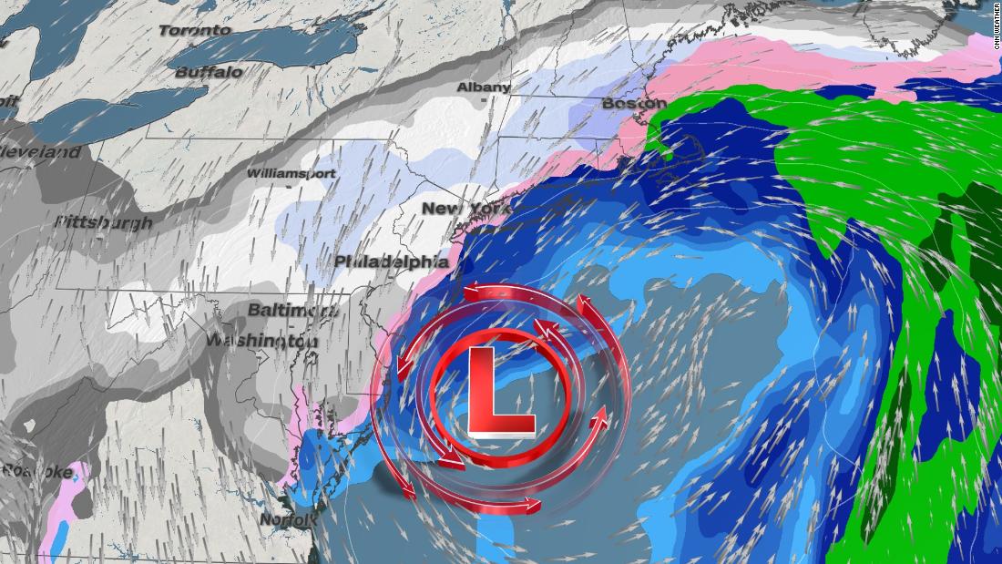
Sunday morning, more than 100 million people were under winter weather warnings from the southern Great Lakes to New England. The impacts of the storm were already felt when heavy snow fell in northern Illinois and central Indiana, causing travel headaches.
The storm will strengthen into a powerful nor’easter by Monday morning when it reaches the coast. This will be a protracted event for many along the East Coast as the system will slowly disappear. The snow will fall in periodic bursts from DC, Philadelphia, New York City to Boston over the next three days, ending gradually from southwest to northeast.
Major effects expected

High winds will accompany the heavy snow, reducing visibility and causing power outages. Travel stoppages will be extended from the ground to the sky as the storm covers roads and runways in fresh snow. Near the Chicago suburbs, a snowfall of 1-2 inches per hour was reported late Saturday night with up to 9 inches of snow forecast by Sunday evening. As the storm moves east, it will reorganize and intensify. The highest snow accumulations will occur from New Jersey to southern New York, eastern Pennsylvania and parts of Maryland, where up to 12 inches of snow is possible.

Ice and sleet buildup is also a concern for parts of North Carolina, Virginia, Maryland and West Virginia. The highest totals are likely to fall north of Charlotte and Raleigh, where up to 1/2 inch of ice is possible.

The warm sector of this storm is causing numerous showers and embedded thunderstorms in the central and southeastern US today. Expect a rainy Sunday in Atlanta before the showers leave the region by the start of the work week.
Areas further west, such as St. Louis and Springfield, Illinois, will see more rain / snow on Sunday evenings. How much snow exactly sticks to the ground remains uncertain.
A week after parts of Iowa were ravaged by snow, the state of Hawkeye was able to see a few more inches by Sunday evening.
A developing nor’easter
“Snow will move from southwest to northeast Saturday evening and early Sunday night, while snow is likely to be widespread by mid-late morning on Sunday,” said the National Weather Service offices in Baltimore and Washington, DC.
From Sunday afternoon to Monday there is the option of a switch to sleet and sleet.
With any nor’easter, there is uncertainty in the predicted snow totals because so much depends on the exact track of the low air pressure.
“There appears to be a consensus among the forecast models that moderate to heavy snow will occur from parts of Virginia to Pennsylvania and New Jersey, but some uncertainty remains about the exact course of the low pressure Monday through Tuesday,” , said Ward. “This will significantly affect the amount of snow falling from New York City to New England. A storm system running parallel to the coast would increase snowfall, while a more eastward path to sea would limit New England snow totals. . “
That could make the difference between seeing four inches of snow or a foot in places like Boston and New York City.
The NWS office in Philadelphia predicts more than six inches of snow with gusts of wind up to 45 mph “causing significant drifting snow.”
The NWS office in Boston had already pointed out the storm and its possible consequences on Friday.
The storm will then hit the coast on Wednesday.
CNN’s Jennifer Gray contributed to this report.